Study Notes
Overview
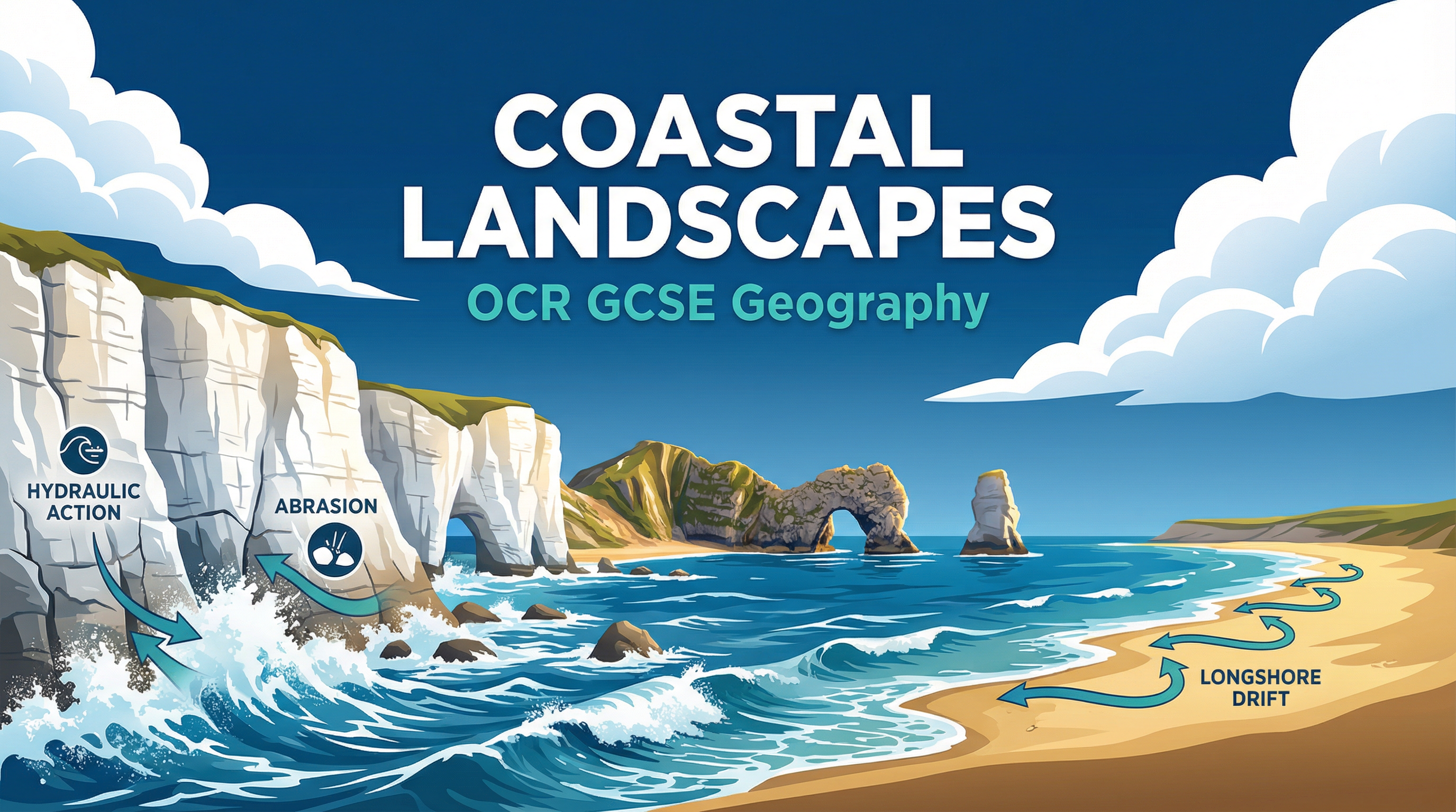
Coastal landscapes are one of the most dynamic and rapidly changing environments studied in GCSE Geography. This topic, a core component of the 'Landscapes of the UK' paper, requires candidates to adopt a systems-based approach, understanding the intricate relationships between wave energy, geological structure, and geomorphic processes. Examiners expect to see a clear grasp of how erosion, transport, and deposition work together to create a variety of distinctive landforms, from towering cliffs and wave-cut platforms to spits and bars. Furthermore, a detailed understanding of a specific UK coastal landscape case study is essential for accessing higher-level marks. This guide will focus on the Holderness Coast, providing the specific data and evaluative points required. Success in this topic hinges on moving beyond simple descriptions to provide sequenced, process-based explanations and nuanced evaluations of coastal management strategies.
Key Concepts: Geomorphic Processes
Wave Types
Constructive Waves: These are low-energy waves with a strong swash and weak backwash. They carry material up the beach and deposit it, building up the beach profile. They are characterised by a long wavelength and low frequency (6-8 per minute).
Destructive Waves: These are high-energy waves with a weak swash and a powerful backwash. They erode material from the beach and carry it offshore. They have a short wavelength and high frequency (12-14 per minute).
Processes of Coastal Erosion
Hydraulic Action: The sheer force of the water crashing against the coastline. When waves strike a cliff, air is trapped and compressed in cracks and joints. As the wave retreats, the pressure is released explosively, weakening the rock over time.
Abrasion (or Corrasion): This is the 'sandpaper' effect. It occurs when rocks and other sediment carried by the waves are thrown against the cliff face, scouring and grinding it away. This is often the most significant erosional process.
Attrition: This process does not directly erode the coast, but instead wears down the sediment itself. Rocks and pebbles being transported by the sea repeatedly knock into each other, becoming smaller, smoother, and more rounded.
Solution (or Corrosion): The chemical erosion of the coastline. Seawater is slightly acidic, and it can dissolve certain types of rock, most notably limestone and chalk.
Coastal Transportation
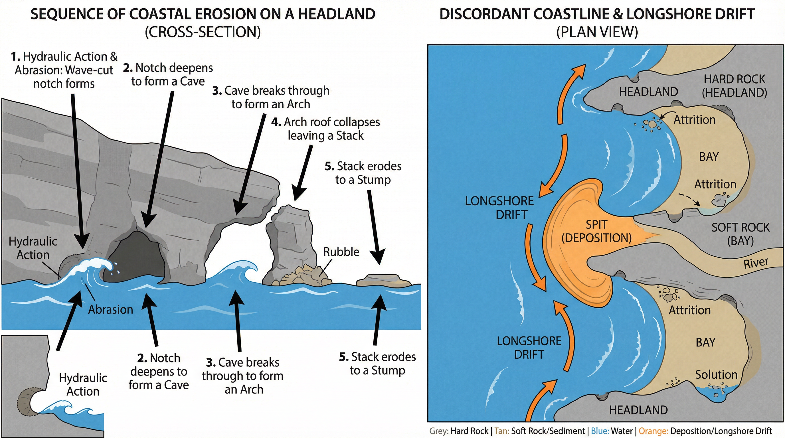
Longshore Drift (LSD): This is the primary process for moving sediment along the coastline. Waves, driven by the prevailing wind, approach the beach at an angle. The swash carries sediment up the beach at this angle. The backwash then pulls the material straight back down the beach at a right angle due to gravity. This continuous zigzag movement transports vast quantities of sand and shingle along the coast.
Landform Formation
Erosional Landforms
Headlands and Bays: These form on discordant coastlines, where bands of hard and soft rock are perpendicular to the coast. The less resistant soft rock (e.g., clay) is eroded more quickly to form bays, while the more resistant hard rock (e.g., chalk) is left jutting out into the sea as headlands.
Cliffs and Wave-Cut Platforms: Destructive waves attack the base of a cliff through hydraulic action and abrasion, forming a wave-cut notch. As the notch deepens, the overlying rock becomes unstable and collapses. This process repeats, causing the cliff to retreat and leaving behind a gently sloping rocky surface called a wave-cut platform, which is visible at low tide.
Caves, Arches, Stacks, and Stumps: This is a classic sequence of erosion occurring on a headland.
- Cave: Weaknesses in the headland are exploited by erosion, widening to form a cave.
- Arch: If the cave erodes through to the other side of the headland, an arch is formed.
- Stack: The roof of the arch is weakened by weathering and eventually collapses, leaving a detached pillar of rock known as a stack (e.g., Old Harry in Dorset).
- Stump: The stack is eroded at its base by the sea and eventually collapses to form a stump, which is often only visible at low tide.
Depositional Landforms
Beaches: The accumulation of sand and shingle deposited by constructive waves between the high and low water marks.
Spits: A long, narrow finger of sand or shingle that extends from the land out into the sea or across an estuary. Spits form where the coastline changes direction and longshore drift continues to deposit material in the same direction. The end of the spit is often curved by secondary winds and waves, forming a recurved end. A salt marsh often develops in the sheltered, low-energy zone behind the spit. Spurn Head on the Holderness Coast is a classic example.
Bars: A bar is a ridge of sand or shingle that has grown across the mouth of a bay, cutting off the sea and forming a lagoon behind it. This can happen if a spit continues to grow across a bay.
Coastal Management
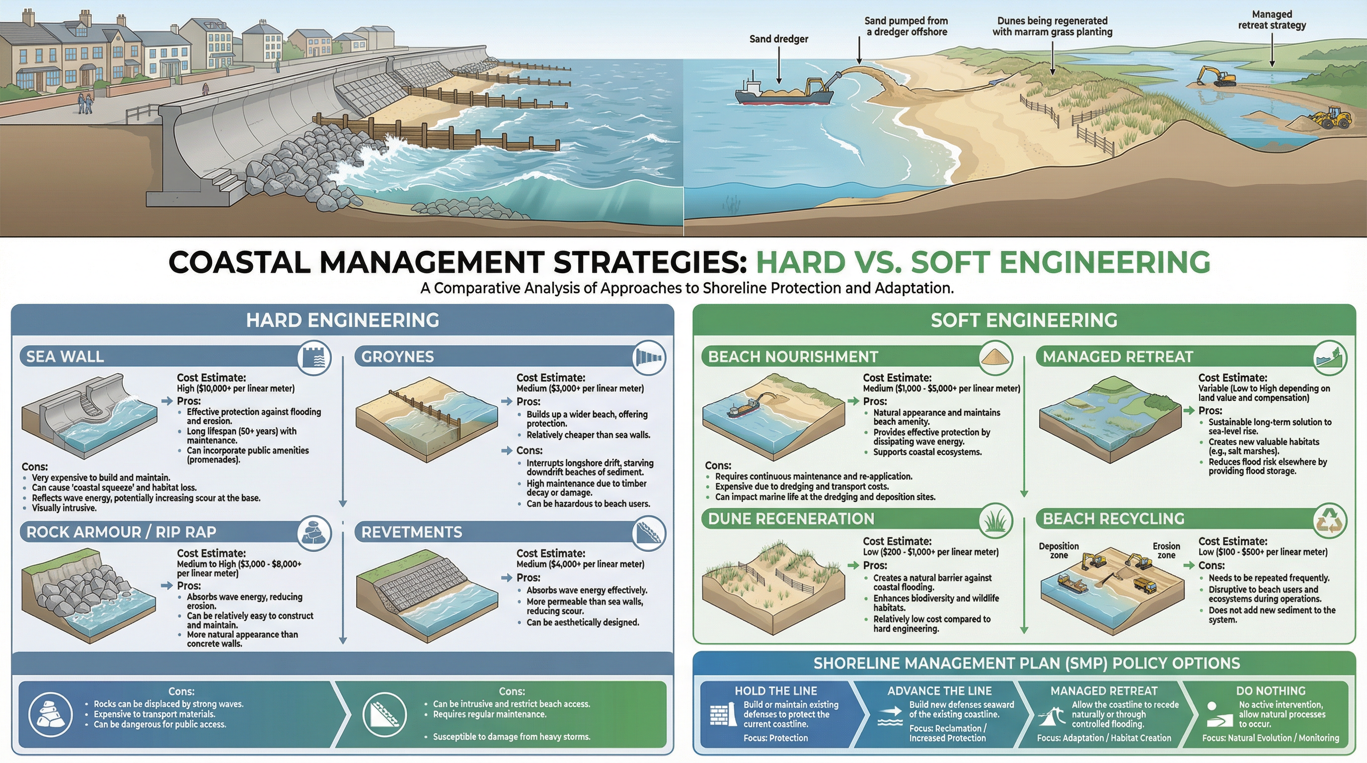
Coastal management strategies are divided into two main types: hard engineering and soft engineering.
Hard Engineering
These are artificial structures designed to control natural processes. They are often expensive, visually intrusive, and can have negative knock-on effects.
- Sea Walls: Concrete or stone walls at the foot of a cliff or top of a beach. They are very expensive but provide excellent protection. Their curved shape reflects wave energy, but this can scour the beach at the base of the wall.
- Groynes: Timber or rock structures built at right angles to the coast. They trap sediment being moved by longshore drift, building up the beach. However, by trapping sediment, they starve beaches further down the coast, increasing erosion there. This is a key point for evaluation.
- Rock Armour (Rip-Rap): Large boulders piled up at the base of a cliff. They absorb wave energy effectively and are cheaper than sea walls, but can be unsightly.
Soft Engineering
These strategies work with natural processes to manage erosion. They are often more sustainable and less visually intrusive.
- Beach Nourishment: Adding large quantities of sand or shingle to a beach. This creates a wide, natural-looking beach that absorbs wave energy. It is expensive and needs to be repeated regularly.
- Dune Regeneration: Planting marram grass to stabilise dunes. The roots of the grass bind the sand together, and the dunes provide a natural barrier to the sea. This is a low-cost, sustainable option.
- Managed Retreat: Allowing the coastline to erode and flood in a controlled way. This is a very controversial but sustainable long-term strategy, creating salt marsh habitats. It is only used in areas of low-value land.
Named Example Bank: Holderness Coast
- Location: East Yorkshire, North East England. Extends for 61km from Flamborough Head to Spurn Head.
- Geology: Predominantly soft, unconsolidated boulder clay (till), which offers very little resistance to erosion.
- Erosion Rate: The fastest eroding coastline in Europe, retreating at an average of 1.8 metres per year. This results in the loss of around 2 million tonnes of material annually.
- Mappleton Case Study: A small village on the Holderness Coast. In 1991, £2 million was spent on two rock groynes and a rock revetment to protect the village and the B1242 coastal road. The scheme has been successful in protecting Mappleton, but has caused sediment starvation downdrift, leading to increased erosion at Great Cowden, where farms and businesses have been lost.
- Spurn Head: A classic recurved spit at the southern end of the Holderness Coast, formed by the deposition of sediment transported by longshore drift.